| August 16 • Ptarmigan Peak Trail |
 In Silverthorne, Colorado, you turn north on Tanglewood Lane next to Wendy's and bear right (east) at every intersection until you're on Ptarmigan Trail Road (County Road 2021). The parking area for the trailhead is easy to find at about 9100 feet no more than a mile from the turn at Wendy's. I hit the trail at 7:20, expecting a long day. In Silverthorne, Colorado, you turn north on Tanglewood Lane next to Wendy's and bear right (east) at every intersection until you're on Ptarmigan Trail Road (County Road 2021). The parking area for the trailhead is easy to find at about 9100 feet no more than a mile from the turn at Wendy's. I hit the trail at 7:20, expecting a long day.
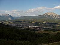
The trail begins in a residential section and quickly climbs out of town into the forest. After about 20 minutes, the trail flattens out a bit. I was glad, as it's discouraging to begin a hike on steep terrain. In about an hour the trail comes to a spot where there's a nice view of town, Buffalo Mountain and Red Peak. There is a log bench someone has built for taking in the view. Nice touch. From here the trail begins to climb in earnest. While it's not terribly steep, it climbs consistantly and there are lots of long switchbacks. The mountainside faces west and occasionally you get a view of the Gore Range to the west. This is a wide, well-maintained trail through aspen and evergreen forest. I saw a deer and managed to get its photo; a rare occurrence for me. Two hours in, at about 11,000 feet the trail breaks out of the forest. Shortly after, it crosses the boundary into Ptarmigan Peak Wilderness and at this point I saw a trail on the right leading downhill. My map had shown a two-trail option in the mid-portion of this climb but I hadn't seen a fork in the trail at lower altitude. The other trail is probably there somewhere but there was certainly no sign or trail marker. I was convinced the trail I had taken was surely the best (and most obvious) route.
I was wishing the new rain jacket I ordered the previous week had arrived before this hike, but made do with the one I had. I skipped the left fork in the trail on the way down. A rainy afternoon seemed a poor time to experiment with an untested trail. The rain let up for a few minutes at a time but was pretty steady until I reached my car at 3:20. |
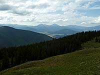
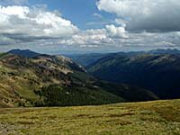 From above 11,500 feet the view south is of Mt. Guyot, Bald Mountain, Lake Dillon and Ten Mile Range. The trail continues up the west side of the Ptarmigan Peak ridge, following an old four-wheel drive trail from before the wilderness designation in 1994. It eventually winds up at the north end of the summit with a nice view of Williams Fork Mountains and South Fork Williams Fork drainage. At the summit of 12,498 foot Ptarmigan Peak by 11:00 I was finally rewarded with the spectacular view to the east of the Continental Divide, Pettingell Peak and Hagar Mountain. While walking around at the summit I saw three White-tailed Ptarmigan, which I thought quite appropriate.
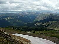 As is typical on a mountain top around noon, clouds were building fast. I shot a 360°